Goal:
The goal of this lab was to use various geoprocessing
tools to locate a suitable environment for the study of bears in an area in
Marquette County, Michigan, using vector analysis in ArcGIS.
Background:
The purpose of this mapping exercise was to map black
bear locations in a study area in Marquette County, Michigan, from a GPS MS
Excel file. Then the goal was to find
what forest types the black bears were usually located in, and also determine
how far they were from streams. Next was
to find habitat that is most suitable for bears based off those two
factors. Then the spaces were narrowed
down to areas managed by the Michigan DNR and to eliminate areas near urban or
built up lands. A data flow model of the
workflow and cartographic output throughout the whole process was then
generated. And lastly there was an
introduction to ArcGIS Python.
Methods:
Task one: First was to create a
folder and geodatabase for Lab 3. Then
unzip the file into the Lab 3 folder, and access the data through
ArcCatalog. The file must first be added
to Arcmap as an “event theme”, then the x and y coordinate data can be added as
a layer, and exported into the geodatabase as a feature.
Task two: All the feature classes
had to be added and arranged properly to start off. Then a summarized spatial join was used to
create a new feature class that included the ID number of the bear and the land
cover type. Then the top three habitat
types were determined by sorting the “count” field by descending.
Task three: Next the locations and
streams classes were spatially joined to determine the number of bears found
within a certain distance of a stream.
The percentage of bears found near streams was significant, suggesting
that streams could be an important factor in bear habitat.
Task four: Now based on the research
so far it was possible to determine habitable environments for bears in the
area. By selecting from the attributes
of the three best land cover types for bears, a feature class could be made to
perform a union with the stream buffer class.
The dissolve tool was then used to get rid of internal boundaries within
the new feature.
Task five: This task was to narrow
down the habitable area to those just within DNR management lands. The intersect tool was used for this, and the
dissolve tool was used again to delete internal boundaries.
Task six: Using the feature created
from task four, the DNR wanted all areas within five kilometers to not be
included in this study area. A feature
containing urban land was created and buffered at a distance of five
kilometers. The erase tool was then used
to delete any overlapping areas between the safe bear habitat and any urban
development.
Task seven: The reports from tasks
four and six were included in producing a map of suggested lands for bear
habitat in the study area. The map
created had to be cartographically pleasing and including all the proper
cartographic elements. It also included
a small locator map showing the location of the study area within Marquette
County, Michigan.
Task eight: The purpose of this task
was to be introduced to python using the ArcGIS Python window. The functionalities of python language in
regard to geoprocessing operations were explored and practiced by writing some
simple commands.
Results:
 | |
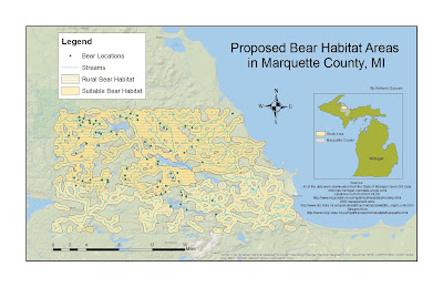
| Figure 3.1 |
This map shows the lands within the study area that are prime black bear habitat. The areas that are more rural are preferred habitat because they are further away from urban development. The map also does a really good job of displaying how vital streams are to their habitat, along with dense vegetation. 72% of the bear locations were within 500 meters of a stream.
Figure 3.2 is a data flow model. It displays a diagram of the steps taken to make the map for Figure 3.1. The blue ovals represent data from the original database, the green ovals represent feature classes created, and the yellow rectangles represent tools and processes used to create feature classes, join data, etc.
 | |||
| Figure 3.3 |
This is the python script written as an introduction to the ArcGIS Python window. Learning about python helps conceptually link how these geoprocessing operations carry out.
Sources:
All of the data were downloaded from the State of Michigan
Open GIS Data http://gis.michigan.opendata.arcgis.com/
Landcover is from USGS NLCD
DNR management units
Streams from

No comments:
Post a Comment